North and South Manitou Islands are the “hidden gems” of Sleeping Bear Dunes Nationals Lakeshore. Because of the time commitment required to visit the islands, many of the visitors to the Park never have the opportunity to step foot on either of them. During the summer, day trips by Manitou Transit ferry leave Leland each day about 10 AM and the boat returns around 5 PM. This gives day visitors a chance to visit the village, lighthouse, and take a tour of some of the historic farms or walk trails or beaches. But to visit North Manitou Island, visitors have to be prepared to camp for a few nights because the ferry will drop campers off and then leave until their next trip.
The islands have similar but significantly different histories. Both islands were used by Native Americans for hunting and fishing and were settled by Europeans in the mid-1800’s to provide cord wood as fuel for the steamships making their way from the Erie Canal to the Chicago area. Both islands became centers for travel and commerce well into the early 1900’s.

South Manitou Island 1871 Lighthouse
South Manitou Island was first settled by William Burton in 1838 as a cord wood refueling station for steamships building a dock in the middle of the deep-water, protected bay. The island had a lighthouse as early as 1839 and the current lighthouse, built in 1871 was the third one built on that site. The US Life-Saving Service commissioned a Life-Saving Station on the island in 1901 and ultimately the US Coast Guard became a significant presence there. The island was also an agricultural center during the shipping era producing some of the finest rye hybrids. When roads were built on the mainland and ships no longer stopped on South Manitou Island, it became financially prohibitive to continue farming on the island. It became a destination for families with cottages on the island.
North Manitou Island was settled in by Nicholas Pickard in the mid-1840’s after much of the forest had been harvested on South Manitou Island. Pickard ran a large cord wood operation until the late 1800’s when the island had been mostly cleared and farming became the main activity. In 1854, North Manitou Island Volunteer Life-Saving Station was built by Nicholas Pickard to provide rescue capabilities for ships in distress in the Manitou Passage. This was the first on the Great Lakes.
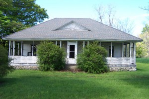
Monte Carlo cottage on Cottage Row – Designed by Frank Lloyd Wright
In 1894, Chicago residents Frederick Trude and George Blossom in cooperation with Blossom’s father-in-law, Silas Boardman created a resort development called Cottage Row where 10 lots were marked off for building sites for summer homes. Cottage Row was set on a ridge overlooking the beach to the east. A lighthouse was built on Dimmick’s Point in 1898.
By 1908 the Smith and Hall Lumber Company began lumbering on the west side of the island and built the village of Crescent with a sawmill, a 600 foot dock, and rail line into the forest. By 1915, most of the land was logged and the operation was shut down. The village of Crescent was vacated. The island came under the management of the Manitou Island Association which maintained a large farming operation, with beef cattle and orchards. They also ran an extensive hunting camp and resort on the island. Logging continued in a selective manner into the 1970’s.

North Manitou Island Life-Saving Service Station
Much more information about the history of the Manitou Islands is available in our visitor Guide which can be downloaded FREE: Manitou Islands 061211. The booklet is also available at the Sleeping Bear Dunes National Lakeshore Visitor Center for a donation of $2.00. In addition, a wealth of historical and biographical information about the families who settled the islands is available on www.manitouislandsarchives.org. This web site is edited by Gene Warner, a descendant of one of the families who lived on South Manitou Island. Be sure you search the Archives and News sections of his web site.
Maps of the islands are available for a FREE download.
North Manitou Island Map
South Manitou Island Map
Maps of the island villages are also available for a FREE download.
NMI Village Visitor Guide 062310
SMI Village Visitor Guide 062310